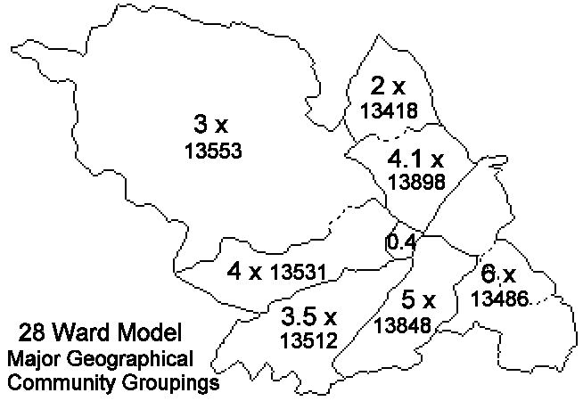
JGH::Docs.Politics.WardReview.NewWards.Submission.Intro.htm | Search |
1.2 The city currently has a population of 530,600 and an electorate of 379,123. The city covers approximately 36,333 hectares, more than 75% being open space or countryside.
![]() |
2.3 A set of proposals for new wards can be made in individual sectors with little impact on other sectors. In fact, any final implementation could very easily use the most appropriate model for each sector from different original submissions, regardless of which overall submission each sector was part of.
2.4 The geography is so distinctive that my model and the City Council’s model have both formed within the same sector model, and I am confidant that any submissions from other parties will fit into very similar geographical sectors.
2.5 Accordingly, this report details proposed new wards for the following six sectors of the city, each of which can be slotted into any other submission to make a complete model:
North-West | bounded by the upper Don valley railway and the River Rivelin |
West | bounded by the River Rivelin and the River Porter |
South-West | bounded by the River Porter and the River Sheaf railway line |
South | bounded by the River Sheaf railway line, Ridgeway Road, Carr Brook and Sheffield Parkway |
East | bounded by Ridgeway Road, Carr Brook, Sheffield Parkway and the lower Don valley railway line |
North | bounded by the lower Don valley railway line and the upper Don valley railway line |
The boundary between the North-West sector and the North sector follows the Parish boundary east of Oughtibridge rather than the railway line. The railway line at this point runs through the centre of Oughtibridge, and so it would cut the community in two.
2.6 As both my model and the City Council’s model have evolved within the same sectors, I have numbered the proposed wards in this model to match the City Council’s numbering scheme for ease of comparison. This summarises which wards are in which sector of the city:
North-West | Wards 1, 4, 5 |
West | Wards 9, 10, 14 |
South-West | Wards 15, 17, 18, 19 |
South | Wards 16, 20, 25, 21, 24 |
East | Wards 13, 22, 23, 26, 27, 28 |
North | Wards 2, 3, 6, 7, 8, 12 |
Ward 1 - North-West | Ward 11 - West | Ward 21 - South |
Ward 2 - North | Ward 12 - North | Ward 22 - East |
Ward 3 - North | Ward 13 - East | Ward 23 - East |
Ward 4 - North-West | Ward 14 - West | Ward 24 - South |
Ward 5 - North-West | Ward 15 - South-West | Ward 25 - South |
Ward 6 - North | Ward 16 - South | Ward 26 - East |
Ward 7 - North | Ward 17 - South-West | Ward 27 - East |
Ward 8 - North | Ward 18 - South-West | Ward 28 - East |
Ward 9 - West | Ward 19 - South-West | |
Ward 10 - West | Ward 20 - South |
3.2 While many Metropolitan Districts are, by definition, predominantly urban there are significant rural areas in many such districts where the requirement for a three-member ward system forces irrational warding arrangements inappropriate to rural areas.
3.3 Most new Unitary Authorities have three-member wards as the norm, but they have the flexibility to have two-member and one-member wards where more appropriate. Legislation to allow Metropolitan Districts such as Sheffield to be treated in the same way would be seen as fairer and would be welcomed by many people involved in the democratic process.
3.4 There have been some suggestions to consider a council size significantly smaller than at present. The City Council initially drafted proposals based on 23 wards as well as 28 wards. I believe that a council size similar to that at present best suits the administration of the council and the representation of residents.
3.5 In 2000 the city council moved from a committee structure to a cabinet/scrutiny structure. At the time it was anticipated that this would result in a lower council workload for elected members. In contrast, many members actually reported an increase in workload, as was submitted in evidence submitted to the 2001 pay review process.
3.6 As an elected member myself I have also noted an increased workload with the new structure. I believe that going to a a 23-ward model would probably result in another 30% increase in workload, and that the new Cabinet system should be allowed to bed in for some years so that real information can be gathered on a suitable number of elected members.
3.7 Both main parties on the council have expressed support for the extension of the present Area Panel system. This will inevitably add to the workload and individual responsibilities of members. The move to cabinet/scrutiny may have removed the committee workload for many members, but it was always the case that the majority of members' workload was made up from casework, planning, licensing, appeals etc. This volume of work remains unchanged with the move to the new system.
3.8 At the Council's public consultation meetings that I attended no members of the public expressed support for a 23-ward model, rather, concern was expressed about the reduced democratic representation that larger wards would entail. Also, larger wards would result in some wards that would be very difficult to manage geographically by elected members and could put elected members out of touch with their constituents.
3.9 I have chosen 28 wards rather than 27 or 29 as a number that gives ward sizes close to the current average and as a number that is likely to better fit into future parliamentary constituencies.
4.2 The City Council’s forecasts show the city centre electorate decreasing from 2582 to 2309 by 2006. However, there are a lot of residential developments rapidly being completed within the city centre which will increase the city centre population. The 2001 register does not list several currently completed developments such as Cornish Place and Riverside. I have estimated an increase in the city centre electorate of about 2500 by 2006, resulting approximately 5000 electors. This is based on the following developments that are actively being completed on the ground:
Dwellings | Electors | ||
Glossop Road Baths | 21 | 33 | |
Regent Street/Terrace | 31 | ||
West One | 466 | 699 | |
Pitt Street | 173 | ||
Royal Plaza | 162 | 243 | |
Rockingham Street | 257 | ||
Morton's | 49 | 74 | |
West Point | 87 | 131 | |
Leopold Street | 30 | 45 | - estimate |
Kelham Island | 98 | 147 | |
Exchange Brewery | 60 | 90 | - estimate |
Cornish Place | 60 | 90 | - estimate |
Riverside | 60 | 90 | - estimate |
St. Paul’s | 30 | 45 | - estimate |
Ward's Brewery | 150 | 225 | - estimate |
Leadmill | 30 | 90 | - estimate |
Other natural growth | 50 | - estimate | |
Total | 2513 |
4.3 City-wide, the average numbers of electors per dwelling is about 1.7 (379,123 electors, approx. 220,000 dwellings). This figure is similar to many district councils across England and other metropolitan authorities in Yorkshire. I have erred on the cautious side in estimating city centre growth and used 1.5 electors per dwelling for developments where a stated occupancy figure has not been given.
5.2 The boundary review is driven by numbers with the aim of electoral parity, but accepts that regard should be had to community ties that may be broken by warding arrangements. Taking communities ties as my main secondary aim, I have tried to put appropriate numbers together in the following manner:
ii) Try to repair splits - if a community has previously been split up in order to make numbers match previously, I have aimed to bring those disparate parts back together again.
iii) Remove anomalies - there are areas where existing boundaries have become defaced or made nonsensical, such as housing development creeping over old boundaries, or rivers being diverted or buried.
In 1997 I produced a set of maps detailing the changing ward boundaries within Sheffield City Council over the 20th century and have been developing an ongoing project to document the electoral changes in Sheffield over its history. Much of my work is available on the Internet at http://www.mdfs.net/Docs/Sheffield.
In 1996 I joined the Liberal Democrats and in 1999 became elected to Sheffield City Council. From study I have an overview knowledge of the geography, history and community groupings across Sheffield and from living in Sheffield and from friends, family, campaigning, leafleting and other contacts have built up a grass-roots knowledge of large areas of Sheffield on foot on the ground.
This is a personal report, and has not been commissioned by any other person or political party. I have discussed and shared as much of my work with other people as they have been interested in. I have regularly sent copies of my drafts to Sheffield City Council officers leading on their proposals, as well as to lead members of the four political parties recently represented on the council, Labour, Liberal Democrats, Liberal and Conservative, and to independent members. I am happy for any other party, grouping or individual to endorse or reject any part of my proposals.
I attended as many of the City Council's public and member consultation meetings as I could get to to listen to and absorb as much of the comments from across the city.
Name: | J.G.Harston |
Address: | 70 Camm Street, Walkley, Sheffield S6 3TR |
Telephone: | 0114 281-8708 |
Email: | jgh@arcade.demon.co.uk |
Web: | http://www.mdfs.net/User/JGH |